-40%
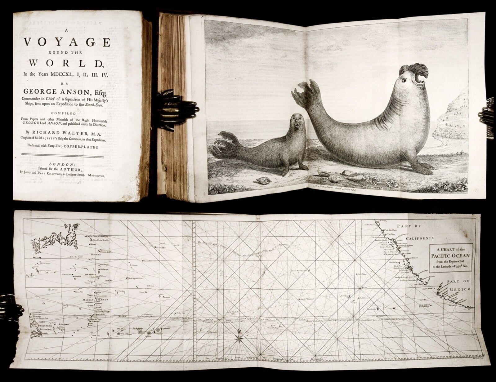
1748 ANSON Voyage 1ST EDITION AMERICA Mexico CALIFORNIA Philippines MAPS PLATES
$ 332.64
- Description
- Size Guide
Description
[Illustrated English books - 18th century] [Maps & Cartography] [Exploration and Travel][South & Central America] [Early Americana] [History of California] [Philippines]
Published, for the author, by John and Paul Knapton, London, 1748.
Text in English. Illustrated with 43 folding engraved plates and maps.
FIRST EDITION, FIRST ISSUE (with page 319 misnumbered 219).
Scarce FIRST EDITION of this masterfully written account which "HAS LONG OCCUPIED A DISTINGUISHED POSITION AS A MASTERPIECE OF DESCRIPTIVE TRAVEL" (Hill). The work quickly became THE MOST POPULAR BOOK OF MARITIME ADVENTURE OF ITS TIME
, and was reprinted several times before the end of the 18th century, but
the original 1748 quarto remains "the most desirable [edition]
" (Sabin)
One of the landmark 18th-century English circumnavigations, Anson's voyage laid the groundwork for the British voyages of exploration in the Pacific of the second half of the 18th century.
Some of the fame of the expedition is due to the published accounts of survivors of Anson's ship Wager, wrecked off the Patagonian coast and vividly described by Bulkeley and Cummins, John Byron, Young, and Campbell.
The precise authorship of the account of Anson’s
Voyage
has long been a subject of debate. It is now agreed that although the ostensible author, Richard Walter, chaplain of Anson's flagship the 'Centurion', took the initiative for publishing, gathering names of subscribers and profiting handsomely from it, it was however Benjamin Robins who completed the editorial task. Sir John Barrow's 1839
Life of George, Lord Anson
claimed that it was, in fact, written by Colonel Benjamin Robins, "an engineer officer of great talent and celebrity". According to Barrow,
"Walter drew the skeleton, and Robins clothed it with flesh and warmth of imagination."
Robin's authorship has been further confirmed with the discovery of an unpublished account of Anson's voyage by Israel Mauduit. A brilliant mathematician, Benjamin Robins (1707-51) came to Anson's attention because of his pioneering work in ballistics (Robin's "New Principles of Gunnery" was published in 1742).
"This is the official account of Anson's voyage.
England, at war with Spain in 1739, equipped eight ships under the command of George Anson to harass the Spaniards on the western coast of South America, for the purpose of cutting off Spanish supplies of wealth from the Pacific area. Lord Anson, who was a friend and patron of Benjamin Robins, after returning from the voyage around the world in the Centurion, appears to have entrusted to Robins, for revision, the account of the voyage which had been compiled from the journals by his chaplain, Richard Walter. It is probable that Robins revised and edited the work, wrote an introduction, and added dissertations.
This compilation has long occupied a distinguished position as a masterpiece of descriptive travel. Anson's voyage appears to have been the most popular book of maritime adventure of the eighteenth century.
" (Hill)
The keenly-awaited book became a best-seller,
running through numerous editions in its full or abridged form and being translated into several European languages.
It exercised wide influence in many quarters, including the Spanish court and the Jesuit circles
. According to Wagner (Spanish Southwest, 132), the
Society of Jesus took offense at the criticism of its behaviour and policies in California contained in the Anson's
Voyage
,
and Venegas' classic Noticia de la California (1757) was, in part, written to refute the accusations that they did not care about the Natives to whom they were supposed to minister.
George, 1st Baron Anson, PC, FRS (1697 – 1762) was a Royal Navy officer, who went on to become First Lord of the Admiralty during the Seven Years' War. Unlike the exploring and scientific voyages that would follow, Anson's voyage was a strictly military expedition, intended to disrupt Spanish commerce in the Pacific and cut off Spanish supplies of wealth from South America after the outbreak of war between Britain and Spain in 1739 (the so-called War of Jenkins' Ear).
Leaving England with six ships manned by about nine hundred mostly green or decrepit crew members, the expedition nearly ended in disaster before it even reached the Pacific. By the time Anson's scattered fleet arrived at Juan Fernandez Island (from which his fellow captain Woodes Rogers had rescued Alexander Selkirk just a few decades before), Anson's force was reduced by more than half.
Six of his fleet's vessels were sunk or wrecked on the South American coast or in rounding Cape Horn after their passage through the Strait of Le Maire, and many of his men died of scurvy. After raiding along the coast and futilely waiting for the departure of the Acapulco ship, Anson turned west for home with only the Centurion and about two hundred crew members remaining. On the way, however, they captured the Manila Galleon near the Philippines, the cargo of which proved to be worth £500,000 sterling, thereby assuring that Anson and all the remaining crew would become rich men on their return to England in 1744.
Anson’s voyage is remembered as "a classic tale of endurance and leadership in the face of fearful disasters
, but to the British public of 1744 it was the treasure of the galleon, triumphantly paraded through the streets of London, which did something to restore national self-esteem battered by an unsuccessful war" (ODNB).
The work has been justly praised for its numerous finely engraved views, charts, and maps, including several of Mexico (plan, view, coast chart of Acapulco, and view and harbor of Chequetan, modern day Zihuatanejo). The intricately rendered
Chart of the Pacific Ocean
with its striking web of rhumb lines is of particular interest. “The names are mostly Vizcaino names except for San Bernardo and the Punta de Nuestra Señora de los Nubes, applied to Pt. San Lázaro.
Numerous errors appear on the map, which, however, was largely copied by later mapmakers, no doubt on the correct assumption that it was based on a genuine Spanish chart. It has occurred to me that San Bernardo is an error of the engraver for Santa Barbara as that name frequently appeared at that time on Spanish charts. He has C. San Bernardino as his starting point for longitude just like Spanish charts of the north Pacific, and Acapulco is in about 134° and Punta Conception in 109°." (Wagner, Cartography of the Northwest Coast of America, 557)
In addition all the 42 large engraved folding plates and maps as called for in this 1st Edition, our example also has an additional folding map (bound as the frontispiece): the ‘
Chart, shewing the Track of the Centurion round the World
’. This map depicts California as an Island, and also shows a partial New Holland, still attached to New Guinea
and with no signs of New Zealand. The map is not called for in the
Directions to the binder
, and was apparently published somewhat later: it is found in some later editions of the work, but occasionally (although rarely) was bound in copies of the 1748 first edition.
Bibliographical references:
Wing V185; Thacher p.525; Arber's Term Cat. I 259.
Physical description:
Quarto; leaves measure 253 mm x 204 mm; bound in contemporary (mid 18th-century) calf, boards with simple gilt fillet borders; spine with raised bands and a gilt-lettered label (old sympathetic reback in 19th-century calf).
Pagination: [34], 417, [3] pages + 43 folding plates & maps.
Misprint in the pagination (page 319 misnumbered 219) indicating the 1st Issue of the 1st Edition.
COMPLETE, including all the plates and maps, the list of subscribers, and the Directions to Binder leaf at the end.
Illustrated with 42 engraved folding plates and maps, including 3 large folding charts: of the
Southern Part of South America
, of
Channel in the Philippine Islands
, and of the
Pacific Ocean
. In addition, including (as a frontispiece) an extra map:
Chart, shewing the Track of the Centurion round the World
(not called for in the list of plates).
Preliminaries include a Dedication to John, Duke o Bedford, a List of Subscribers, a table of contents, Errata, and an Introduction, Included at the end of the volume is a 2-page list of plates (
Directions to the Bookbinder for placing the copper-plates
).
Provenance:
A gift inscription (To Henry [?…] from his Affectionate Father, dated Feb. 7, 1810) to front fly-leaf.
With an ex-libris bookplate of Richard Harington dated 1891 to front pastedown. Sir Richard Harington, 12th Baronet (1861 – 1931) was educated at Eton and Christ Church, Oxford. Called to the Bar in 1886, he practised as a barrister on the Oxford Circuit before taking up an appointment as judge in the High Court of Justice at Fort William in Bengal in 1899, where he served in that capacity until returning home in 1913. He had, meanwhile, served in the London Brigade of the Royal Naval Artillery Volunteers from 1880 to 1891, and had commanded the Artillery Company of the Calcutta Port Defence Volunteers from 1900 to 1909. He volunteered for the Royal Naval Volunteer Reserve on the outbreak of the First World War in 1914, aged 53. He was promoted to the rank of Chief Petty Officer in the Anti-Aircraft Corps, in which capacity he served until 1916. A onetime Justice of the Peace and Deputy Lieutenant for Herefordshire, he was appointed High Sheriff of Herefordshire in 1918.
Condition:
Good+ antiquarian condition. Complete. Binding somewhat rubbed, with some scuffs, superficial scratches, and wear to edges; spine sympathetically rebacked in the 19th century; joints with minor wear but intact and quite solid, boards firmly attached. Textblock with some marginal damp-staining to the (blank) bottom corner of the outer margin, generally quite harmless, only causing light fraying and minor chipping at the lower (blank) fore-corner of the title-page, the preliminary leaves, about 10 leaves at the end of the volume and margins of a few plates (text and engravings not affected!). Occasional light browning; occasional offsetting of printed text. A few folded plates with minor closed tears without any loss (most of which discretely and neatly repaired at an early date). In all, a solid, genuine, well-margined example of the rare 1st/1st edition of one of the most important travel books of the 18th century.
Please right-click on thumbnails below and choose "open image in a new window" option to see larger images.
